LUCIFS
Development of population density and of the size
of areas of agricultural use between the 6th millennium BC
and the 3rd century AD
Team: Prof. Dr. Andreas Zimmermann, Dr. Karl Peter Wendt, Johanna Hilpert M.A. (University of Cologne, Institute of Prehistoric Archaeology, Weyertal 125, D-50923 Cologne).
The main task of the archaeological project within Rhine-LUCIFS is to calculate the amount of open land (farmland) during specific periods of time beginning with the Neolithic (5.500 BC) to the end of the Roman Empire (395 AD). These data will be compared with the results on sediment degradation- and accumulation processes by the geographic projects. A hierarchical model to combine archaeological and archaeobotanical knowledge of different scale levels is developed to estimate regionally differentiated estimations of population densities (fig. 1).

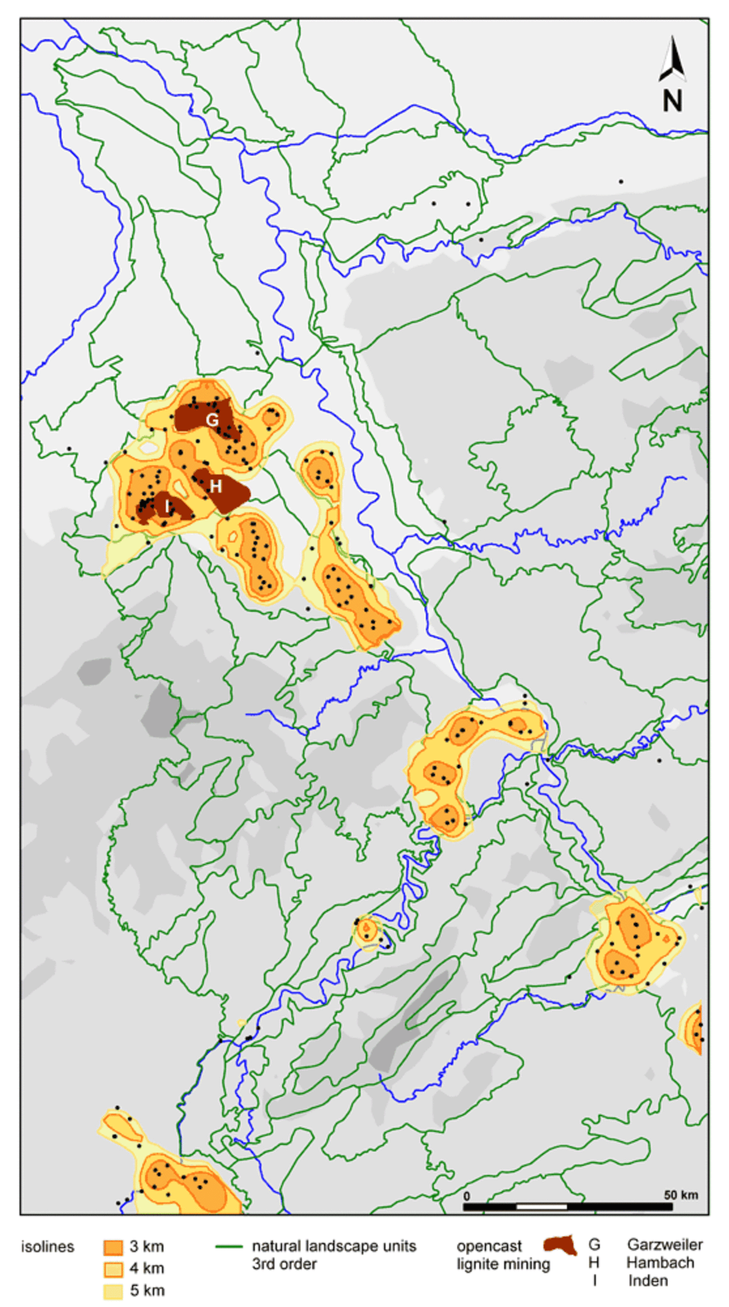
Calculations of population density allow estimations of the size of arable land because prehistoric Europe is based on subsistence production. Also a statement concerning the openland woodland ratio is possible. A combination of methods is used to upscale chronologically and regionally differentiated data from well-researched small areas (key areas) to larger regions with less precise data until the level of the river Rhine catchment is reached. Basic data for the Bandkeramik at the smallest scale is the archaeological knowledge of the number of houses. Most important are the excavations of the last 30 years in the eastern "Aldenhovener Platte" (part of the open cast lignite mining area between Cologne and Aix la Chapelle). Another key area is the "Mörlener Bucht" north of Frankfurt a.M. (Schade 2004). In these areas results a density of approximately 1 houshould per square kilometer in the middle of the 51th century B.C. At a larger scale the density of sites is needed for the estimation of the population density. It is determined by constructing Thiessen polygons around individual Bandkeramik settlements. The distance of the polygon-nodes to the next nearest site is taken to represent the prevailing density value (fig. 2).
On the basis of these values a new method has been developed to transform site distribution points into settlement patches as clearly defined "settlement areas". These are enclosed within optimal isolines (fig. 3).
The optimal isoline is ascertained by comparing the increase in space by the specific isolines. The increase of space is compared for the isolines between 3 and 7.5 km distance between sites (in other periods of time up to 15 km). The optimal isoline is characterised by a maximum increase of space (fig. 4 and fig. 5).
Historical Atlas of the Rhineland: Bandkeramik | ||||||||
| Sites | Area (sqkm) | |||||||
| Site Distance (km) | Number of areas | Number | Percent | Increase per km | Difference | Size | Increase per km | Difference |
| 3 | 17 | 144 | 62.1 | 16 | 990.8 | -257.496 | ||
| 34 | 1132.38 | |||||||
| 3.5 | 13 | 161 | 69.4 | 2 | 1557.0 | -275.3 | ||
| 32 | 1407.68 | |||||||
| 4 | 10 | 177 | 76.3 | -2 | 2260.8 | 158.36 | ||
| 34 | 1249.32 | |||||||
| 4.5 | 7 | 194 | 83.6 | 12 | 2885.5 | 183.78 | ||
| 22 | 1065.54 | |||||||
| 5 | 8 | 205 | 88.4 | 14 | 3418.2 | 20.28 | ||
| 8 | 1045.26 | |||||||
| 5.5 | 8 | 209 | 90.1 | 0 | 3940.9 | -31.86 | ||
| 8 | 1077.12 | |||||||
| 6 | 7 | 213 | 91.8 | 6 | 4479.4 | 165.5 | ||
| 2 | 911.62 | |||||||
| 6.5 | 7 | 214 | 92.2 | 0 | 4935.2 | 31.9 | ||
| 2 | 879.72 | |||||||
| 7 | 6 | 215 | 92.7 | -4 | 5375.1 | 28.88 | ||
| 6 | 850.84 | |||||||
| 7.5 | 8 | 218 | 94.0 | 4 | 5800.5 | -24.7 | ||
| 2 | 875.54 | |||||||
| Total | 232 | |||||||
Fig. 4. Site density, size of embedded areas and the increase of both data by isoline and the difference of the increase between two isolines
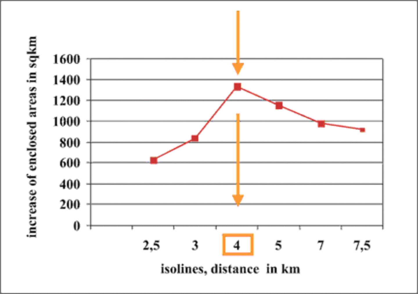
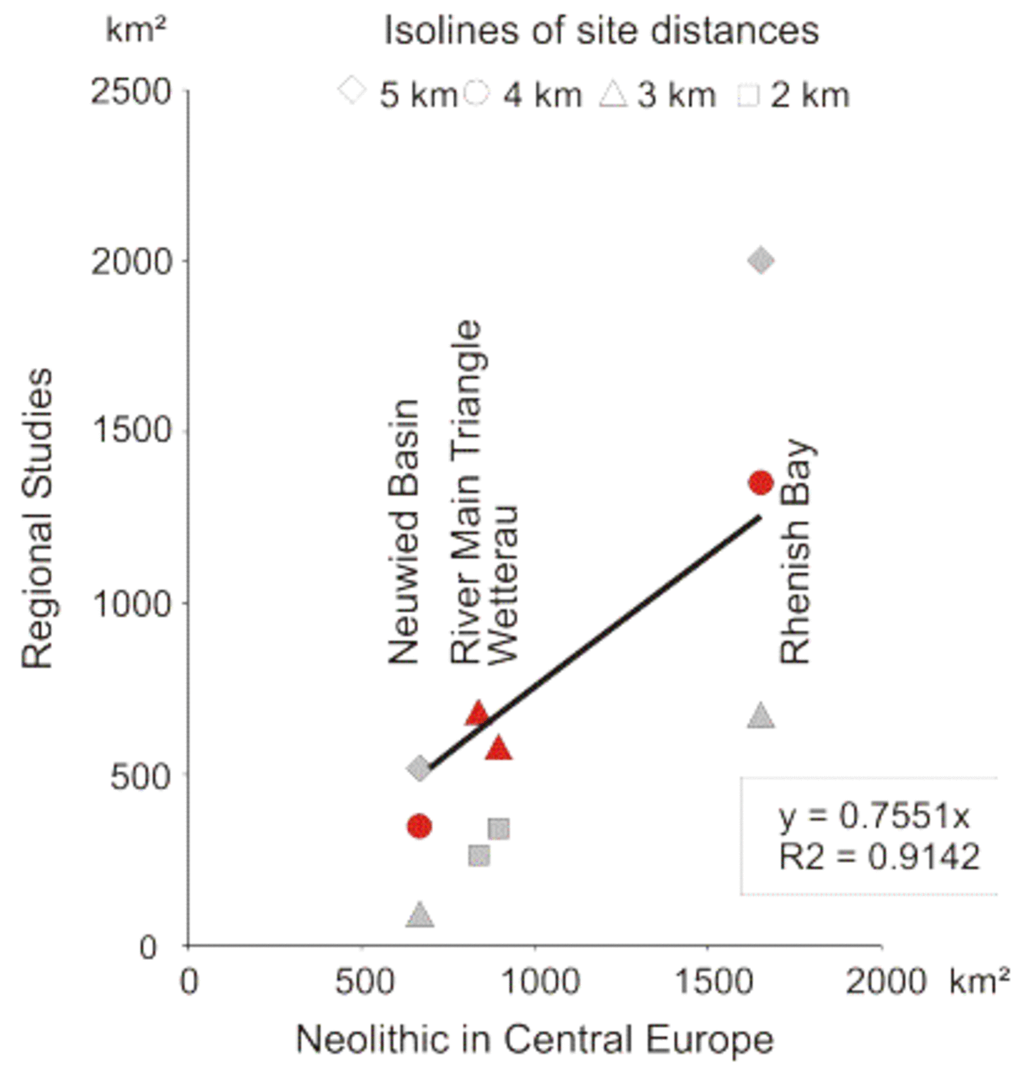
It seems reasonable to assign the density of households determined for the key areas "Aldenhovener Platte" to the 4-km isoline to the entire lower Rhine catchment area. In this area a population density of 0,44 persons per square kilometer is obtained, if an average of 6 persons lived in a Bandkeramik house. For the Linearbandkeramik Culture (LBK), the population density and the size of farmland are upscaled to the level of the entire river Rhine catchment. Input for the largest scale is a point distribution map of the Bandkeramik in middle Europe (1:2.500.000; Preuss ed. 1998). At this scale the 3 or the 4 km isoline is the optimal one. Using the 4 km line results in settlement areas 1.3 times as large as the corresponding areas of maps at smaller scale. One of the reasons is the spatial precision error of the large scale map which renders interior empty spaces, such as larger river valleys, invisible. This effect is neutralised by using a regression analysis (fig. 6).
The upscaling process is controlled by data of other key areas like the Maindreieck and the northern Wetterau. In the German Rhine catchment existed approximately 6000 houshoulds in the middle of the 51th century B.C. It is intended to work out similar estimations of population density using data of other periods (Hallstatt D/La-Tène AB, Roman Empire). In these cases the algorithm of upscaling has to be modified, because in these times specific properties are to be considered (farmland in the lower mountain range during the Iron Age and the specific structure of the Roman period with urban centres, villae rusticae, military camps and an elaborated infrastructure). Parameters like soil are used to verify the results of the analysis. It will be further controled by the results of the palynological project which provides an independent estimation of the intensity of human impact.
References
- A. J. Kalis, A. Zimmermann, Anthropogene Einflüsse auf die Umwelt: Eine kanonische Korrespondenzanalyse von prähistorischen Pollenspektren. In: J. Müller und A. Zimmermann (ed.), Archäologie und Korrespondenzanalyse. Beispiele, Fragen, Perspektiven (Espelkamp 1997) 179-182.
- J. Preuss ed., Das Neolithikum in Mitteleuropa (Weissbach 1998).
- F. P. Preparata, M. I. Shamos, Computational Geometry. An Introduction. (New York 1988).
- J. Richter, E. Claßen, Neolithikum. Geschichtl. Atlas Rheinlande. Beih. II 2.1 2 (Köln 1997).
- C. C. J. Schade, Die Besiedlungsgeschichte der Bandkeramik in der Mörlener Bucht / Wetterau. Zentralität und Peripherie, Haupt- und Nebenorte, Siedlungsverbände. U.P.A. Band 105 (Bonn 2004).
- A. Zimmermann, Zur Bevölkerungsdichte in der Urgeschichte Mitteleuropas. Tübinger Monographien zur Urgeschichte 11. In: I. Campen, J. Hahn und M. Uerpmann (ed.), Spuren der Jagd - Die Jagd nach Spuren. Festschrift Müller-Beck (1996) 49-61.
- A. Zimmermann, Landschaftsarchäologie I: Die Bandkeramik auf der Aldenhovener Platte. Ber. RGK 83, 2002, 17-38.
- A. Zimmermann, J. Richter, Th. Frank, K. P. Wendt, Landschaftsarchäologie II. Überlegungen zu Prinzipien einer Landschaftsarchäologie. Ber. RGK 85, 2004, (in press).
- A. Zimmermann, K. P. Wendt, Wieviele Bandkeramiker lebten 5.060 v. Chr.? Techniken Geographischer Informationssysteme zum Schätzen von Bevölkerungsdichten. Archäologische Informationen 26/2 (2003) 491-497.